


Many general contractors, subcontractors, and other decision-makers in the construction sector use lidar technology to make more accurate, data-driven decisions. This cutting-edge technology could reach a $1.5 billion value in the construction industry by 2030. Here's a quick rundown of lidar systems and how they facilitate construction project planning.
What Is Lidar?
Light detection and ranging is a laser-based, remote sensing technology that collects data for mapping digital elevation and 3D models. Geographical information systems use it to develop digital terrain or elevation models for 3D mapping.
Lidar sends a laser from a transmitter, reflecting light from objects in the scanned environment. The system's receiver detects the reflection, then uses flight time to create a 3D map of the on-site objects. Lidar can streamline various applications within the building construction market.
Here are some characteristics that make lidar systems unique:
- Lidar has a self-contained light source, unlike cameras that rely on ambient light.
- Lidar doesn't only measure distance — it captures an object's entire size and shape.
- Lidar offers faster and more accurate measurements than radar technology, allowing for real-time applications.
How Lidar Technology Works
While lidar sounds complex, the concept behind this technology is straightforward — point a small laser at a surface, then measure how long it takes for the laser to return to the scanner.
As each pulse returns to its source, it calculates the distance between the sensor and the surface, such as a building, using the velocity of light. The outcome is a single point in space. These individual points combine to create a 3D visualization called a “point cloud.”
Lidar scanners can emit millions of laser pulses per second, so a point cloud may contain billions of points. The scanner automatically combines the horizontal and vertical angles captured by the laser beam, creating a precise set of 3D coordinated measurements.
Processing this data can give you a digital 3D model that accurately represents the scanned site. The denser the points, the more detailed the picture, offering superior visibility for tiny details and features.
Types of Lidar Scanners
There are multiple types of lidar systems.
- Terrestrial: Terrestrial lidar scanners operate from the ground, scanning objects and capturing data in multiple directions. You can use the collected data to create 3D models, conduct building surveys and other applications.
- Mobile: Mobile lidar scanners mount onto moving vehicles like cars, trains and boats. They can obtain millions of 3D design points per minute. This form of lidar is ideal for 3D mapping and autonomous driving solutions because it can gather denser coordinates, yielding more detailed images.
- Airborne: An airborne lidar scanner mounts onto an aircraft, such as a drone or an airplane. It emits light pulses to the ground, measuring the landscape's dimensions and distances. Airborne lidar systems include topographic and bathymetric scanners. Topographic scanners monitor and map an environment's topography, while bathymetric scanners measure the depths of bodies of water.
Lidar in the Construction Industry
Here's a glimpse of the different ways lidar systems can facilitate the construction process.
1. Project Planning and Land Surveying
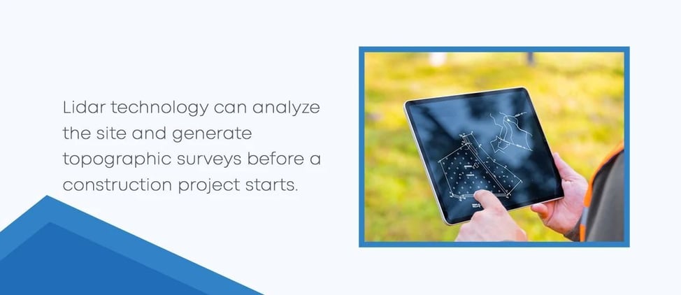
Lidar technology can analyze the site and generate topographic surveys before a construction project starts. It provides engineers and architects with critical data like slope gradient, elevation, existing structures and flood risks, which are critical in project decision-making.
Additionally, construction supervisors can integrate lidar data with building information modeling systems to develop detailed 3D models of construction sites. They can then use these models to simulate different scenarios and make more informed decisions.
Lidar can aid various aspects of project planning.
- Aerial inspections: Lidar can integrate with drones and unmanned aerial vehicles to inspect the site from elevated heights, capturing details like civil infrastructure, power lines and other industrial assets.
- Forestry and land management: Lidar can calculate the density of forest canopies. Decision-makers can then use this data to assess environmental impact, fire prevention planning and other land management strategies.
- Surveying and mapping: Lidar can develop precise digital elevation models for GIS, benefiting surveying and mapping applications.
2. Project Cost Estimations
Because lidar helps construction teams acquire accurate site representations, construction managers can better predict costs and budget accordingly. Lidar reduces the risk of unforeseen expenses emerging in later project phases, as construction crews can obtain the necessary materials, tools and equipment in advance.
3. Building Restorations and Renovations
Restoration project construction crews must exercise caution to avoid disrupting the building's structural integrity, individuality and charm.
Lidar provides a noninvasive way to assess and survey historical structures and heritage buildings, capturing the intricate details needed to execute these restoration projects. Additionally, it can help construction teams identify areas in existing buildings that require renovation, offering detailed insights into their current conditions.
4. As-Built Drawings
As-built drawings make it easier for construction teams to ensure the original design plans align with the final specifications. Lidar has become foundational in developing these essential documents due to its incredible accuracy and ability to capture detailed spatial data.
Lidar streamlines the creation of as-built drawings by generating precise 3D models of the final construction. Construction crews can then compare these models against the original plans, ensuring the structure meets the predetermined requirements and identifying discrepancies. Catching these errors early helps construction teams avoid expensive alterations down the road.
5. Site Monitoring and Maintenance
Lidar can help construction teams beyond the initial planning stage. It can monitor conditions and detect potential risks, such as deformation or collapse.
Decision-makers can then use this feedback to pinpoint areas requiring reinforcement or renovation. Lidar can assist construction and renovation projects, helping crews ensure structural longevity and keep up with maintenance needs.
Harness Innovative Construction Technologies With BuildingPoint SouthEast
With lidar and other modern solutions reshaping the construction industry and project planning, your team can benefit from adopting new technologies into your operations. At BuildingPoint SouthEast, we're passionate about helping construction companies enhance their workflows with advanced, accessible and intuitive technology.
As an exclusive Trimble dealer, we offer various options, including 3D laser scanning systems, mixed reality and more. We'll work with you to find tailored solutions for your construction challenges, boosting efficiency across your site.
Explore our field solutions and learn more about what we can do for you. For more information, contact us today to request a quote or demo.